MOUNTAIN BIKE TOURS AT BIKE-CIRCUS SAALBACH
Awesome bike trails in the province of Salzburg
Saalbach: Where mountain bike dreams come true
The extensive offerings of the MTB region Saalbach gets mountain bikers going: 400 km of mountain bike trails. Bikepark Leogang, for example, is one of the biggest and most action-packed bike parks in Europe.
The ultimate holiday combination of biking and adventure holiday. A one-of-a-kind worldwide, breathtaking network of MTB trails at all difficulty levels ensures that cross-country, pleasure and soul riders, freeriders and downhill experts all get their money’s worth.
Here you’ll find mountain bike trails at the “Home of Lässig” in Saalbach:
Monti Trail, the former Milka Line – the freeride trail for families & beginners located directly at the hotel. This new bike trail powered by Milka for bikers of all ages and for soul riders in Saalbach Hinterglemm has been around since 2011. The approx. 3-km-long trail leads across generously dimensioned laylines and small wooden elements from the Kohlmais intermediate station to the valley. The Milka Line is designed for beginners and allows everyone to get a start for freeriding with lots of ease and fun.
Length: 2.9 km
Altitude difference: 380 m
Highlights: easy, wide trail with generously dimensioned turns, small wooden elements
Characteristics: Milka photo point, “Lila Pause” and flat Northshore elements
One of Europe’s longest freeride routes!
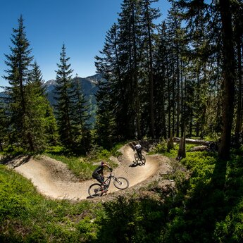
The X-Line curls from the mountain station to the valley station of the Schattberg over 6 km and down 1,015 m of altitude difference making it one of the longest freeride routes in Europe. The diverse, close-to-nature trail with numerous tree root passages gives bikers – from soul riders to downhill pros – their money’s worth.
The upper part confronts bikers with a flowing singe trail with grand panoramic view of the valley. The part leading into the valley from the Schattberg intermediate station is more challenging, containing many Northshore elements and tricky trails. Having almost arrived downhill, you can decide between an easy-going descent to the valley station or the adapted adidas Slopestyle Run.
Length: 6.3 km
Altitude difference: 1,015 m
Highlights: Time yourself!, Northshore trails, adidas Slopestyle Run, step-downs, funny table line
Characteristics: highly diverse, close-to-nature single trail crosses meadows and forest floors with jumps, tree root passages and tricky technical passages. High fun factor for versed bikers – but also many alternatives for pros.
Calling all freeriders: The new BIG 5 Bike Challenge in Saalbach, the Grande X-Trema, is only for you!
One full day of freeriding on the hottest single trails only for the toughest freeriders under the Glemm Valley sun.
5,000 altitude metres in one day? Impossible to overcome? The cable cars of Saalbach-Hinterglemm and Leogang make it possible. There’s a special ticket for the BIG 5 Bike Challenge – available at our reception.
Length: 72 km
Altitude difference: approx. 1,000 altitude metres uphill and approx. 5,000 altitude metres downhill
Difficulty: hard tour in terms of conditioning and riding technique
A challenging nature trail
The Bergstadl Trail is the more challenging alternative to the Hacklberg Trail offering constant technical finesse. It branches off the legendary Hacklberg Trail after about 300 m, squeezes through the avalanche barriers and curls through idyllic postcard scenery directly to the Bergstadl. The frequently very narrow, labyrinthine and root-heavy trail is a genuine challenge for even for well-versed bikers and those looking to become better who don't shy away from challenges. A completely new routing awaits you, starting at the Westgipfelbahn intermediate station leading across wide meadows, past the Resort Buchegg and the Gerstreit Alm and eventually back down into the valley.
Length: 3.1 km
Altitude difference: 600 m
Highlights: gorgeous alpine panorama, many technical passages
Characteristics: technically challenging, close-to-nature single trail in a beautiful mountain scenery with stone and rock passages
Non-stop action on the Zwölferkogel.
The start of the new Z-Line (powered by TREK) is directly next to the Zwölferkogelbahn intermediate station in Hinterglemm from where the Z-Line powered by TREK curls down into the valley with a breathtaking view of Saalbach Hinterglemm. The approx. 4.5-km-long route is pretty much predestined for ambitious freeriders looking to let loose on the freeride route. It knocks the socks off touring riders who have conquered the mountain on their own and are looking for a somewhat different downhill run. The laylines, wall rides and drops all come with bypass options. Tables, waves and Northshore elements were installed in a manner that allows for easily rolling over them at low speed, too. A spectacular souvenir photo, taken by the Action Snapshot Station automatically, awaits passing bikers just before the finish line.
Length: 2.7 km
Altitude difference: 450 m
Highlights: Action Snapshot Station, wall rides, connection to pump track and riding safety area Wieserauberg
Characteristics: highly diverse route through amazing mountain scenery, also suited for practised touring riders with corresponding safety equipment
One of the most beautiful single trails in the valley.
The Hacklberg Trail from the Schattberg in Saalbach across the western summit to Hinterglemm is one of the most beautiful single trails in the valley. Starting right behind the Westgipfelbahn mountain station, the single trails speedily leads down a long grassy ridge to the Hacklbergeralm. Next follows a forest road to the Westgipfelbahn intermediate station – Bergstadl, from where well-versed bikers can choose between the forest road or the challenging shortcuts.
Length: 6 km
Altitude difference: 600 m
Highlights: upper section speedy single trail with gorgeous panorama, tricky tree root passages after the Bergstadl
Characteristics: flowing single trail that can be taken at high speed, technical passages in the lower part
2 trails in one - for PRO and rookie
Pros and beginners, freeriders and downhillers all get their money’s worth on the two freeride trails PRO & BLUE Line on the Reiterkogel. There’s something from everyone, from doubles to steep turns to Northshore variations, tree root passages, fat drops and jumps. Just drop in and give it a shot.
The BLUE LINE was rather designed for beginners, yet it offers lots of fun to speed junkies as well. It provides steep turns, small jumps and flat Northshore elements, giving every rider the right flow. It’s decisively easier to bike than the PRO LINE.
BLUE LINE
Length: 2.6 km
Altitude difference: 428 m
Highlights: Northshore elements, flow trail
Characteristics: flowing course for hobby riders with lots of flow and fun
Adidas Freeride PRO Line
Length: 2.3 km
Altitude difference: 428 m
Highlights: Evil Eye Trail, drop variations, risk of addiction!
Characteristics: challenging and diverse single trail across forest floors and rocky parts with jumps, Northshore trails, tree root passages and technical passages
